Everything seemed to be falling into place for a two day severe weather episode, so Dustin and I decided to head to the NE, IA border to catch some action. Initially, Wednesday seemed to be the day that was going to an appetizer as the orientation of the upper level trough was still positive and less progressive than the progged upper level flow for Thursday. We basically figured that any convection we could catch Wednesday would be icing to the cake. In summary, Wednesday turned out to be better than Thursday despite the better looking atmospheric conditions on Thursday (more on this later).
After reviewing some data while stopping at Sonic in Des Moines, IA, our initial target was Aurora, NE. While driving to our target we noticed many storms firing of to the west of Aurora near Kearney and Grand Island. We still decided to keep our target due to the very agitated nature of the cumulus clouds outside our windows between Lincoln and Aurora. To our liking, a pair of supercells fired along this northward lifting boundary and put us in the perfect position to chase.
 Initial storm north of Aurora, NE, lacking strong low-level inflow
 The TIV (Tornado Intercept Vehicle) contemplates on a target
Storms seemed to be lacking a low-level inflow, and with darkness approaching we decided to call it quits near Lincoln, NE. While checking into our hotel, many mexican men were standing outside of the entrance to the hotel amazed by the wind, rain and lightning from the leftover convection. Did I also mention that they were downing 24 oz. beers? Sure enough, we found one of them with a phone up to his ear passed out on the steps leading up to the room.
Yes hunny, I'll make it home for breakfast tomorrow.
After a few laughs, we noticed that the lightning on the backside of the convection we were following was amazing. Must say that it was the best display of anvil zit lighting that I have seen to date.
 "Anvil Zits" outside of Lincoln, NE
 Dessert after the main course.
After returning to the room, attention quickly turned to Thursday's chasing prospects. After waking up to the largest Storm Prediction Center high risk that I have ever chased, I was anxiously awaiting the afternoon convection. Even though the morning high risk was primarily for a threat of damaging wind, it was apparent that a small area in E central NE was becoming ripe for tornadic supercells (see MD below).
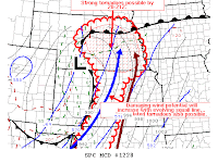
Mesoscale Discussion issued shortly after we left Lincoln
I will now go into quite a bit of detail about Thursday's bust...
After choosing York, NE as a target we noticed some convection starting to fire on radar to our west near Grand Island and we immediately traveled west to scope out the action. It was obvious that these storms were not tapping the uncapped surfaced based instability that the SPC mesoanalysis was showing (see below).
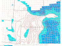
17 Z Surface Based CAPE
 Notice the lackluster appearance of the convection along the boundary in S central NE
 What was happening? You can clearly see that the storms in northwestern KS were thriving in an environment that seemed much less favorable for supercellular convection. After a few minuets of watching this convection moving out of CO and into KS, we decided to try to intercept these quickly moving supercells, with a flying V appearance on radar, as they would hopefully move near the Red Cloud, NE area. The pair of supercells was moving into a very favorable environment rich with extreme theta-e and backing winds along a N-S oriented pseudo dryline. All I could keep thinking is that this was it, these were going to be the storms that we have been waiting for... We made it to Red Cloud, NE with time to spare and fueled up while watching radar. We were very curious to see what was going to happen when these storms hit the boundary and moved into a much better conceptual severe storm environment. The radar scan after the storm hit the boundary, and I mean right after, the storm immediately lost all of its rotation and started to dissipate into a non-severe shelf cloud. WHAT? Hmm...You would THINK that this storm was moving into a much more favorable environment. What was wrong with the airmass on the east side of this boundary? It was clearly having trouble sustaining any sort of an updraft the entire day. One hypothesis could be that the airmass to the east of this boundary was capped despite the RUC's analysis in the SPC mesoanalysis. Wouldn't this boundary help break that cap?
What happened when the supercell that looked so good on radar hit the boundary? Boundaries are supposed to be areas of enhanced vorticity and wind shear. Was it the orientation that storm crossed the boundary that made it dissipate and turn into a shelf cloud? So many questions were running through my mind on the long drive back to Illinois...One thing for sure is that we as meteorologists still know very little as far a mesoscale processes in these sorts of situations. Who knows, maybe someone will do a case study for the event, but I find it unlikely due to the lack of 18Z soundings behind this psuedo dryline... Now 0-5 while chasing high risk events and 0-4 inside of PDS tornado watches. I'm becoming more frustrated every time I see a high risk...one. It always seems like there is just way to much going on!
Disappointingly, the best picture of the day
Time lapse of the shelf cloud
 Anvil shield from the early afternoon convection to the west
 Penny to walnut size hail!
 Posing with a handful of small hail

 Notice the precip core on the left side of the storm rather than the right...

 Reflection of CB off of the lake
 Dad posing next to his pride and joy
 Curly enjoys the evening
 This guy was hard to photograph!
 Reflection of CB off of the lake
 Dad posing next to his pride and joy
 Curly enjoys the evening
 This guy was hard to photograph!


