
Thursday, December 10, 2009
12/8-12/9 Snowfall
Wanted to show a cool visible satellite image (click to enlarge) of the vast snow cover from the 12/8-12/9 mid-latitude cyclone. Neat features such as Lake Winnebago, WI, Harlen Co. Lake, NE, and many of the Midwest rivers and their tributaries show up quite nicely.

Sunday, August 30, 2009
2009, The Year Without a Summer?
Many folks in the Great Lakes / Northeast region have deemed this year as the "one without a summer." Take a look at the graph below showing the temperature departures from the latest 30 year average for Rockford, IL. After cool, dry northwesterly flow to the start of May kept severe weather and temperatures cooler than average across a good chunk of the central/eastern U.S., temperatures quickly bumped up to well above average in the back half of June under periods of southwesterly flow (and hence an increase in moisture & severe weather reports). For the majority of July and August, the Great Lakes and Northeast region have been back under northwesterly flow aloft. Sometimes, this flow aloft can be interesting in the mid August time period as MCSs (and occasionally derechos) can be spawn near the upper-level jet stream. However, this flow has lasted for such a long time (and has been so deep latitude wise) that cold fronts have routinely made it to the central Gulf of Mexico. This has in turn left the Midwest with well below average dewpoints for the majority of July and August, and thus little severe weather to talk about.


Thursday, July 9, 2009
7/10/2009 Forecast
Quick look at a composite chart I've made for tomorrow. Any severe weather will be highly dependent on the amount of instability we recieve in the green shaded area.

Sunday, July 5, 2009
Henry, IL Fireworks
Couple shots of Henry's fireworks from the 4th...


Joe & Kade pose at the carnival
Commute (Metra)
Time lapse of Metra's UP-W line from Ogilvie transportation center to about Elmhurst.
Thursday, June 25, 2009
Tuesday, June 23, 2009
Chicago Hustle & Bustle
Monday, June 22, 2009
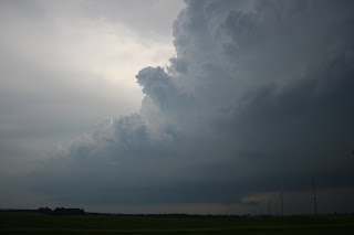
6/22/09 Highway 20 Tornadoes
Sunday featured an interesting set-up for tornadic supercells in central IA along a northward advancing warm front. After a late start, Hampton IA was our initial target. After hopping on HWY 20 west of Waterloo, IA we busted west to catch up with some cells forming near Fort Dodge, IA. As we pulled up to these cells, a nice wall cloud formed and after some organization, produced a tornadic circulation east of Owasa. After heading east to watch another circulation forming near Dike, IA, we kept heading east to stay ahead of the slowly moving storms. We were able to see the tornado with debris cloud that hit structures in Dike, but the pictures turned out to be non-existent as the contrast was terrible. Oh well. We chased visual the entire day with help from Gilbert Sebenste and Alan Black giving us radar updates over the phone, as I didn't have the power cord for my laptop...Argh! (Thanks to them...) Gilbert navigated us south after the Dike, IA storm south to another tornadic supercell heading for Iowa City. After busting through precip, we were once again treated with nice juicy inflow, and as the long exposure shows, a HP supercell. Not bad for a Sunday chase!
I will update with a time lapse from todays activities when I have time.
 Initial wall/funnel cloud near Owasa, IA
 Storm begins to get a nice clear slot
 Touchdown near Cleaves, IA
 Cleaves, IA take two
 Cleaves panoramic shot
 Sharp flanking line heading into the Cleaves storm
 Night view of a supercell near Nichols, IA
6/19/09 DeKalb Sunset
After a round of severe weather over much of Illinois, DeKalb was treated with a beautiful sunset on the back side of an eastward advancing MCS.

Monday, June 8, 2009
6/7/2009 What the Hail?
On Sunday, NIU alum Dustin Oltman and I ventured out to the Middle Mississippi Valley to try to catch some tornadic supercells since this year has been such a bust for me. I was happy to get out and try my luck in a place that I have never chased (nor do I want to again...). Despite crappy terrain/roads, we were able to cross the Mississippi River into NE Kansas and catch up with a beautiful slow moving LP supercell in Jackson county Kansas. This cell had some awesome structure and a very intense updraft! After watching this cell develop an inflow band and attendant wall cloud, it started to weaken and we decided to catch up with a supercell that looked awesome visually just to our south (we chased most of the day without internet, Argh!). This storm had some of the largest hail I have ever seen (up to baseball size on the ground after at least 15 minuets of melting). This storm also went on to produce grapefruit size hail in the town of Guthrie, Missouri. About the best day you can have without getting a tornado!
 Same position as above, looking SE to another large mushroom supercell


Storm 1 (I need a wide angle lens! This thing was awesome...)
 Significant hail in Richardson county Nebraska

Intense updraft of an LP cell (looking west) in Pawnee county NE
 Same position as above, looking SE to another large mushroom supercell
Storm 1 gets an organized inflow band and wall cloud

Storm 1 (I need a wide angle lens! This thing was awesome...)
 Significant hail in Richardson county Nebraska
Saturday, May 23, 2009
5/17-5/18 Friends in the Foothills
Monday & Tuesday provided "down" days for storm chasing in the great plains. Being so close to CO already, I decided to stay with friends from the 2007 NWC REU that now go to grad school at Colorado State University in Fort Collins, CO. This was my first time to the foothills and I must say it was quite impressive. I was able to sample the local cuisine/beer before heading out for the NE panhandle on Wednesday.
 Looking down to the CSU Atmospheric Research Campus
 CSU Football Stadium
 Yep, you guessed it...we went right past the sign!
 Foothills/Man made lake/Horsetooth mt.
 Looking down to the CSU Atmospheric Research Campus
 CSU Football Stadium
 Yep, you guessed it...we went right past the sign!
 Foothills/Man made lake/Horsetooth mt.
Saturday, May 16, 2009
It's May right?
Thursday featured a down day with hope on Friday for a severe weather episode in south central KS before a cold front scours the Gulf of Mexico all the way to the Yucatan peninsula and kills any possibility of severe weather for the next 5 days. Instability was again high with weak wind shear (similar to every set-up this May). After looking at some data in Medicine Lodge, KS, I decided to drift northward to intercept a line of developing cells just north and east of Pratt. These storms were ugly to say the least and featured a shelf with very cold outflow. This week has again verified multiple times that it is much better to have a balance of instability and wind shear rather than just oodles of one...While following these cells all the way back to Braman, OK, my vehicle decided that it was going to make my evening interesting. An inner tie rod (part of the steering assembly) broke and sent me skidding off the road. After waiting for 2 hours for a tow truck, I was towed back to a garage in Wellington, KS. As if this wasn't enough, it was pouring down rain with cloud to ground lightning striking profusely from above. Needless to say, I was not a very happy camper last night! I did grab some photos from yesterday and the vehicle is now back in working order. Whew!
 Typical view of the approaching shelf
 Shelf passing overhead. Looking south towards Conway Springs, KS
 Looking east out of the whales mouth
 Typical view of the approaching shelf
 Shelf passing overhead. Looking south towards Conway Springs, KS
 Looking east out of the whales mouth
Thursday, May 14, 2009
5/13 Have you seen my soopercell?
Wednesday featured an interesting set-up for severe storms in west central OK as a cold front was rapidly plunging southeast into a very unstable airmass (see 18z OUN sounding below). We were certain the cap would break at some point and that severe storms would break out along the front, however, the tornado threat appeared low given the very crappy speed shear. Sure enough, storms initiated in close proximity to our target of Canton, OK and quickly became severe thunderstorm warned for large hail (some members of the V2 project ended up with shattered windshields). We stuck with the "tail end charlie" isolated storm and watched with frustration as it would never really get its act together. You could tell these blobs didn't have a chance to produce tornadoes as inflow into these storms was probably less than 10 mph. Argh! Anyway, we played with an interesting lowering shown below until the sun started to set where we then headed to Binger, OK to sample the hail core under a shell gas station awning. Nickels to quarters was the verdict...As expected, the tornado threat started to increase as better low level shear was introduced via the low-level jet. Too bad this is a nocturnal phenomena! I am convinced that if shear was a little better, this would of been an outstanding day...
 18z OUN sounding. CAPE...check, Shear...hmm
 18z OUN sounding. CAPE...check, Shear...hmm
Cu timelapse near Canton, OK
 Unorganized lowering...Inflow was very crappy...
 A few "anvil zits"
 Rain wrapped TVS just south of our location. Whew!
 Unorganized lowering...Inflow was very crappy...
 A few "anvil zits"
 Rain wrapped TVS just south of our location. Whew!
Wednesday, May 13, 2009
5/12 CIN sucks!
Yesterday featured a set-up of wasted ingredients with a stout cap in place over much of the great plains. Not much time to tell a long story today, but we intercepted a cell near Tuila, TX and dropped south to catch another cell near Plainview. Followed this cell all the way to just north of Childress, TX where we caught up with the VORTEX2 clan.

 Long exposure just north of Childress, TX
 Polarized view of a pretty cell north of Childress
 "Crawler" lightning near Childress
 Convergence!

Morning target forecast
 Long exposure just north of Childress, TX
 Polarized view of a pretty cell north of Childress
 "Crawler" lightning near Childress
 Convergence!
Sunday, May 3, 2009
Morel Mania
Sunday's beautiful weather allowed for one of my favorite springtime hobbies, morel mushroom hunting! Unfortunately, we didn't find enough to make a huge meal, but we did find some of the larger morels that I have seen come out of the woods near our home. My dad and sister found over a dozen about a week prior to today, but we still wanted to check the same places due to the favorable morel weather that has existed this spring so far. Morel's like warm nights and ample rainfall (like many fungi). We've had no shortage of precipitation in Illinois this spring!
 A few Morel's from Sunday's hunt
I will be leaving some time this week/end for storm chasing in the plains. This year, you will be able to track my storm chasing location in real time here. Stay tuned for updates!
Sunday, March 8, 2009
Early Season Severe Weather Setup
On Tuesday morning, showers and thunderstorms will be ongoing north of a stalled warm front near the Interstate 72 corridor in association with strong convergence as the low-level jet impinges on the 850mb warm front. I don't really see this activity being severe as soundings during this time period are totally saturated and lapse rates marginal. Soundings actually look more tropical than anything, and would expect the main threat from this early morning activity to be flooding with more heavy rain likely added to already saturated soils. On Tuesday afternoon, a shortwave trough will eject out of the Southern Plains and become negatively tilted as it passes through the upper Midwest. At the surface, an elongated area of low pressure will house an advancing warm front near the Interstate 80 corridor and an advancing cold front near the IA/IL border. Perhaps the most interesting feature during the late morning and afternoon is the presence of very dry in the mid-levels of the atmosphere. This slot of dry air will be advected over a the early morning high RH air-mass, and as this slot of dry air begins to make its way into the area (around 18Z or so), clouds should begin to thin and allow for some sunshine in these areas. If this materializes, instability in the warm sector will quickly increase as temperatures rise with the passage of the surface warm front and dewpoints rise from moisture advection and the evaporation of the morning rainfall. With the center of surface circulation near central IA at this time, surface winds in a majority of places in central Iliinois will have a southerly to southeasterly component (even south of the WF). Just 1 km above the surface winds at this time will be howling near 50 knots out of the southwest creating ideal directional shear in the lowest levels of the atmosphere. I see "mini" or "low-topped" supercells as the greatest threat with this system in central and west central IL as the thermodynamic environment will struggle to become unstable. Given the ample directional shear and dry air aloft, I see damaging winds and isolated tornadoes as the main threat. Not to mention storms will probably already have a forward moving component that is already near severe criteria. However, severe hail would certainly be possible given rotating supercell updrafts, but lapse-rates in the lowest 3 km are not all that impressive and may be one limiting factor to this entire setup. However, I plan to chase since I am on spring break, and am currently targeting near or just west of Galesburg, IL.
 My "Convective Outlook" for Tuesday March 10th.
 My "Convective Outlook" for Tuesday March 10th.
Thursday, February 19, 2009
Unique Snow Bands
 Click to Animate
This mornings visible satellite showed a unique pattern of snowfall across the Upper Mississippi Valley. After some review of the features present and some collaboration with forecaster's at the NWS in Davenport, IA, it seems as if a very small mesoscale wave produced enhanced lift in a banding effect as noted by the multiple parallel lines almost evenly spaced. It also looks as if the fetch was ideal for the band furthest to the west to have some river enhanced moisture in NE IA and SE MN. Thus, this band furthest to the west is brighter than the others due to its enhanced snowfall. Not a single model picked up on this very tiny mesoscale feature. One good reason to leave a chance of precip in your forecast!
Subscribe to:
Posts (Atom)
