Friday, December 16, 2011

New Diagnostic Weather Data Webpage

Friends interested in meteorology:

It is often taught that meteorologists should first diagnose what is currently occurring in their forecast location, why it is occurring, and how it will impact a future forecast. However, it has been my experience (there are likely differing opinions here) that many forecasters today love to skip right to the forecasting step, without taking the time to make a proper diagnosis of what is currently occurring in the atmosphere. They have become so dependent on products (e.g., model QPF) without a proper understanding of how or why the model is generating precipitation. Unfortunately, this model "cancer" has left these forecasters with nothing more than a crutch on which to blame their failed forecast. Don't misunderstand me, computer models are certainly the best tool for forecasting as they can solve fundamental atmospheric equations far more efficiently than any human. However...

What good is any forecast without a proper diagnosis?

Would you purchase a block of shares in a company based solely on a projected stock price? I sure hope not!

Would a good doctor give you medications to treat a disease without some sort of diagnosis?

As you know, there are plenty of graphs and charts on they web that provide diagnostic information for meteorologists (e.g., surface maps, sounding plots, cross section analysis; I have over 10 pages bookmarked!) However, if you are like me, you are often left saying, "What about other fields," or perhaps more commonly, "there has to be a better way to present such data." Personally, I find many plots hard to read, rather cluttered, or just plain visually unappealing. IMO this is partly due to the fact that many people and organizations that present such data care more about ease of production and content rather than the presentation of that data to the user. Surely content is important, but it is ultimately how the user will interpret that data that makes all the difference in the forecast process! Of course, the main challenge here is that personal preference differs amongst forecasters. Some forecasters like a particular color scale, others do not. Some are colorblind. Some cannot interpret a map that is too cluttered. This is similar to one of the main challenges facing graphics design artists!

Last spring I set out on a mission to create appealing maps and provide unique diagnostic fields that I have trouble finding elsewhere on the web. You'll see that many of the maps I provide are nothing more than "pretty colors" to the untrained eye. However, I've tried to make the graphics as visually appealing as possible without sacrificing content (maybe they don't appeal to you; that's fine too!). I'll be the first to admit that the use of a map with a pretty color scale and neat graphics means little if the user fails to interpret it correctly. Unfortunately, this is not a skill you can develop overnight (just ask a veteran forecaster). My favorite reminder of this comes from Bosart (2002):
If you don't like a particular map or would like an alternate color scale, e-mail me and I'll see what I can do. That is one of the [only?] benefits of working on such a product by yourself).

Okay, now for the goodies:

The URL for the new page can be found at http://vgensini.myweb.uga.edu/wx

Fields currently offered:

Observational (Based on Sounding or Surface Stations)
  • 300, 500, 700, 850 mb isosurface
  • 0-500m MLCAPE
  • Precipitable Water
  • 12h 500mb Height Change
  • Sounding profiles for selected upper-air stations
  • Surface stations
  • 2m θe
  • Surface moisture flux divergence
  • Cross Sections: KGGW - KLCH ; KLBF - KWAL
  • Isentropic analysis at various θ levels
RUC Initialization Fields (00h Forecast; Interpolated to a 211 AWIPS grid ~80km)
  • 300, 500, 700, 850 mb isosurface
  • 300 mb Divergence
  • 500 mb Absolute Vorticity
  • 500 mb Absolute Vorticity Advection
  • 500 mb Absolute Vorticity and Water Vapor (my personal favorite)
  • 700 mb Absolute Vorticity Advection
  • 700 mb Frontogenesis
  • 500-700 mb Layer Average Q-Vector Divergence
  • 500-850 mb Wind Crossovers
  • 850 mb Temperature & Moisture Advection
  • Trenberth Forcing Term
For more information on the fields, visit the metadata link.

Perhaps my favorite aspect is the ability to select the "ani" versions of these products to easily mouse over previous hours to provide an animation of the trends in the field. This trend analysis is key in a proper diagnosis.

I'm still struggling a bit with exactly how I want to display the hyperlinks to the products. I'm not a big fan of the current frames approach I am using, but the UGA student web-server is currently limited (no access to php). Perhaps this format change in the future when this page migrates to a new web hosting solution.

Enjoy!

Monday, October 24, 2011

4km WRF-ARW Test Simulation

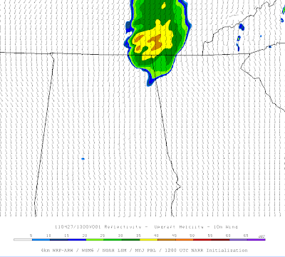
I apologize in advance for all of the acronyms in this post. Actually, no apologies neccessary since this is my own blog ;-) I've attached an animation of a test 4km WRF-ARW simulation of the outbreak of severe convection in the Southeast U.S. on 27 April 2011. The 24-hour run is initialized with 32km data from the North American Regional Reanalysis (NARR) @ 1200 UTC. Parametrizations include: WSM6 MP, NOAH LSM, MYJ PBL, and RRTM radiation. 1km AGL reflectivity (Dbz; fill) and updraft helicity (> 50 m^2/s^2; contour) are displayed. Nothing too fancy that hasn't been done before...just a test.

(click to animate)

4km WRF-ARW forecast sounding for KBHM valid 2300 UTC 27 April 2011

0-1km SRH > 300 m^2/s^2 in the presence of CAPE > 2,000 J/kg. Yowzers!

Tuesday, September 6, 2011

Another Failure of the Warning Process

During Labor Day 2011, remants of Tropical Depression Lee spawned a preliminary count of 13 tornadoes across FL, GA, NC, SC, and VA. This is not uncommon of land-falling tropical systems, but this setup in particular was favorable for rotating updrafts in northeast quadrant of the cyclone. As the afternoon progressed, a small cell formed near Newton county and began racing northeast towards the University of Georgia (Athens, GA). What happened next was yet another example of multiple aspect failure in the warning and information dissemination integrated process (note: there are many storm warning and response examples that are both good and bad. Many of these will never be reported on in the news, unless they happen to be a media-defined tragedy. Thus, this is simply a documentation of one of the many failures I have seen in recent years).

The cell in question prompted a tornado warning at 4:43 P.M. EDT from WFO FFC:

BULLETIN - EAS ACTIVATION REQUESTED

TORNADO WARNING
NATIONAL WEATHER SERVICE PEACHTREE CITY GA
443 PM EDT MON SEP 5 2011

THE NATIONAL WEATHER SERVICE IN PEACHTREE CITY HAS ISSUED A

* TORNADO WARNING FOR...
EASTERN CLARKE COUNTY IN NORTHEAST GEORGIA
OCONEE COUNTY IN NORTHEAST GEORGIA
NORTHWESTERN OGLETHORPE COUNTY IN NORTHEAST GEORGIA

* UNTIL 530 PM EDT

* AT 442 PM EDT...NATIONAL WEATHER SERVICE DOPPLER RADAR INDICATED A
SEVERE THUNDERSTORM CAPABLE OF PRODUCING A TORNADO NEAR
WATKINSVILLE...MOVING NORTHEAST AT 30 MPH.

* OTHER LOCATIONS IN THE WARNING INCLUDE BUT ARE NOT LIMITED TO
BOGART...WHITEHALL...ARNOLDSVILLE...CRAWFORD AND WINTERVILLE.

PRECAUTIONARY/PREPAREDNESS ACTIONS...

WHEN A TORNADO WARNING IS ISSUED BASED ON DOPPLER RADAR...IT MEANS
THAT STRONG ROTATION HAS BEEN DETECTED IN THE STORM. A TORNADO MAY
ALREADY BE ON THE GROUND...OR IS EXPECTED TO DEVELOP SHORTLY. IF YOU
ARE IN THE PATH OF THIS DANGEROUS STORM...MOVE INDOORS AND TO A
BASEMENT OR INTERIOR ROOM ON THE GROUND FLOOR. STAY AWAY FROM
WINDOWS. IF DRIVING...DO NOT SEEK SHELTER UNDER A HIGHWAY OVERPASS.

THIS IS AN EXTREMELY DANGEROUS AND LIFE THREATENING SITUATION. THIS
STORM IS CAPABLE OF PRODUCING STRONG TO VIOLENT TORNADOES. IF YOU ARE
IN THE PATH OF THIS TORNADO...TAKE COVER IMMEDIATELY!

IF YOU SEE WIND DAMAGE...LARGE HAIL OR SIGNIFICANT FLOODING...WAIT
UNTIL AFTER THE STORM HAS PASSED...AND THEN CALL THE NATIONAL WEATHER
SERVICE TOLL FREE AT 1 8 6 6 7 6 3 4 4 6 6.

A TORNADO WATCH REMAINS IN EFFECT UNTIL 1100 PM EDT MONDAY EVENING
FOR NORTHERN GEORGIA.
&&
LAT...LON 3373 8330 3370 8340 3372 8344 3380 8349
3390 8364 3391 8363 3397 8354 3393 8351
3393 8342 3390 8339 3402 8330 3400 8322
3405 8313 3403 8311 3401 8305 3404 8296
TIME...MOT...LOC 2044Z 215DEG 28KT 3382 8333

$

Here is an animated .gif of the lowest-tilt BREF (left) and SRV (right) just before and during the issuance of the warning from FFC (click to enlarge).

What's sad is that so-called "storm based" warnings have been in effect since 2007! There is clearly no immediate threat to western Oconee county, yet the polygon would certainly indicate otherwise to the untrained eye. Additionally, the warning text mentions "strong to violent" tornadoes possible with these storms! Really? Violent tornadoes without a sustained supercellular mesocyclone?

While this particular failure lies in the hands of the warning forecaster, how about an investigation into the dissemination of this information from the NWS to a typical user (in this case, we will examine a typical student at UGA). Remember that for the integrated warning process to be successful, all facets must execute their responsibilites promptly and correctly. Most students are signed up to receive SMS text message alerts and phone calls from UGA in the event of an emergency. In this particular example the UGA campus was not in the tornado warning polygon issued by FFC, nor was there an immediate threat of a tornado. However, somewhere deep in the crappy policy drafted by UGA, it *probably* states that sirens will be sounded and campus put on alert when Athens-Clarke county is put under a tornado warning. Regardless, the emergency plan was activated, and I received a text message alert to my phone at 4:49 P.M. EDT:

Recall that the warning was issued from the NWS at 4:43 P.M. EDT. So, 6 min. passed before I received the alert from UGA. While I have no way of knowing if this time fluctuates from event-to-event (this is my first emergency alert), I can say that 6 min. is unacceptably slow for a tornado warning. In fact, in at least half the cases, this 6 min. would expire the lead time of warning issuance by the local WFO effectively giving the user "no warning." As if that was not enough, the UGA emergency call alert happened 5 min. post-text at 4:54 P.M. EDT:

By now, 11 min. have passed since the warning issuance from FFC. Yes, there may be challenges to getting information to that many students in a timely manner, but it would fail miserably in the case of a real tornado emergency. I mention all of this to say that we *have* to become smarter on all integrated warning fronts. We have the technology to do this! GPS location + GIS mapping software can easily determine if you are in the defined threat area. In fact, our technology of software development (e.g., radar displays) have far outpaced our technology in the branch of warning dissemination (the two are nearly night and day IMO). Of course, none of the information dissemination really matters if we keep seeing foolish cover-your-@$$ type warnings from local WFOs...

Wednesday, August 31, 2011

Bayes' Theorem

An elementary example of applying Bayes' theorem in meteorology can be found here. Enjoy!

Thursday, August 25, 2011

Forecast Precipitation from Hurricane Irene

Millions (50-60+?) of people are going to be impacted by Irene...


Sunday, July 24, 2011

Trip 5 "Other"

For me, formal storm chasing has ended for the season (20,000+ mi. since May 1!). Here are some category "miscellaneous" photos taken during CoD's storm chase trip 5. I'll still be blogging during the offseason with cool pictures and videos as they arise, so check back often!
This scene sums up many roads across South and North Dakota this year
Trip 5 participants...great group!
Mean looking rotation near Bowdon, ND
Time to sacrifice!
Burn baby burn!
Moon hanging like a jewel in the sky (somewhere in SD)
My definition of "Dirt Road Anthem"
Dine and Jamie in front of a canola field (Near Medicine Hat, Alberta)
Cloud droplets can look so comfy at times!

Sunday, July 17, 2011

7/16/2011: Bowdon, ND Tornado

After a sacrifice to the weather Gods, trip 5 managed to document a tornado near Bowdon, ND yesterday. This was certainly the highlight of the trip, and I am glad that many good people got to experience their first tornado with us! In the morning/early afternoon, it was uncertain what the exact forcing mechanism was going to be for convective initiation (see afternoon MCD). However, by late afternoon, it became clear that sustained supercells were going to grace our presence. We targeted the first cell showing signs of convective battering near Bismarck, and raced for our morning target of Bismarck to Jamestown. While we were a little "late" to the party, this cell produced a nice stovepipe tornado ~ 5 southeast of Bowdon. We hung with this cell for the remainder of the day, but it couldn't establish more signs of strong low-level rotation (see time lapse). We stuck around to watch lightning for a little while before calling it a night in Fargo. More pictures of the entire trip when I return home...


Time lapse can be found here.

Friday, July 8, 2011

7/9/2011 Bismarck (HP) Bombs

Friday marked the first day chasing with CoD’s trip 5 (last trip of the year for CoD; sort of a last moment decision for me as I have a lot of research going on). We overnighted in a pretty swag Comfort Inn in Black River Falls, WI, before making a long journey to our target of Bismarck, ND. The long haul paid dividends, as we were treated to a meaty HP supercell near Solen, ND. The storm tried to produce a tornado several times before crossing the river, but just could not get circulation to the surface. The rapid vertical motion was rather impressive, just missing a downdraft/clear slot to impinge on the “sucking scud.” Additionally, it appeared that the low and mid-level circulations were not in harmony at times.

If you have ever visited this area, you are probably aware of the limited places available to cross the Missouri River (crossing in Mobridge, SD & Bismarck, ND; none in-between). Thus, we had to let the cell push east as we busted through the rear flank back north to Bismarck. By the time we caught back up to the cell near Lebanon, ND, it surprised us with some more rapid vertical motion and appeared as if we may get our treat just before dark. Unfortunately, things rapidly fell apart and the cell congealed into the quickly eastward moving MCS activity. We are staying in Aberdeen, SD tonight with eyes on southern SD into NE tomorrow. Stay tuned!


Animation of this setting can be found here. (Best chance for tornado occurs near :17 s mark)

Tuesday, July 5, 2011

6/25-7/1 Gatlinburg, TN Adventures

It took 25 years, but my first trip to the Smoky Mountains proved to be one for the memory bank. I had the opportunity to hike to the top of Mt. Leconte (elev. 6593'), whitewater raft, and zipline! If that wasn't excitement enough, I took Jenna to Grotto Falls and proposed to her! She was very surprised/excited, and I couldn't be happier. Enjoy the pictures and videos!
Panny view from Cabin
Grotto Falls...She said yes!
Mama black bear is hungry!
Rainbow Falls
Rainbow falls (slow shutter speed)
Matthew and Whitney scale the base of Rainbow Falls
Tony taking in the view from the side of Mt. Leconte
Panny from S side of Mt. Leconte
What a view!

Additionally, here is a day and night timelapse from our deck.

Wednesday, June 22, 2011

6/20/2011 Almena, KS & Stamford, NE Tornadoes

6/20 featured an interesting "cold core-ish" type set up in the central Great Plains with another SPC moderate risk for severe weather. Walker and I enjoyed breakfast at our overnight hotel (Ramada Inn) in Kearney, NE before deciding to venture southwest to intercept some elevated convection moving our way out of northwest KS. On our drive toward this cell, we stopped for lunch at a local diner (Frosty Mug) in Franklin, NE, and closely watched the evolution of this cell. After lunch, we decided to go after this cell after it appeared to quickly become surface based. It was a little tough to get "suckered" south into KS, as the 1630 Z SPC tornado risk (and most of the high-resolution model guidance) suggested that the environment along and northwest of I-80 in central NE would become quite favorable for tornadoes during the late afternoon and evening. Nevertheless, we continued to chug towards this cell. It turned out to be a good decision, as the now surface based supercell ended up producing several tornadoes, including a beautiful half-dust ingested tornado south of Almena, KS. I was in charge of taking video while Walker took stills (days like these can be very stressful alone, and it was great to have another person in the car). Thus, you'll have to wait for Walker's post for the (IMO great) still photos. Until then, enjoy the video and suboptimal pictures that I have uploaded. I apologize for the jerky video in some parts as the wind was pretty intense. We followed this cell north ending up near Stamford, NE, and along the way we witnessed several tornadoes that quickly became rain-wrapped. We eventually broke off with this storm (it was our original plan to do so), to catch up with convection firing further E along and north of I-80. I suspect that this convection didn't have the same storm-relative directional shear that was present with our initial storm (inflow winds were northeasterly into Almena/Stamford storm, while storms to the east were in an environment characterized by southeasterly surface flow) and thus failed to "produce." One of the more interesting features throughout the day were the numerous small (what appeared to be) forward flank mesovorticies. These vorticies exhibited tornadic rotation and often produced swirls of dust at the surface. Certainly a day that I will never forget. We ended the day in Lincoln, NE feeling like champions. Kudos to Walker for helping navigate a rather poor road network along the KS/NE border...look for his post in the offing.
Rain-wrapped barrel tornado (end of Hill City, KS wedge that Mike U. witnessed)
New emerging meso and attendant tornado
Video capture of needle-cone tornado S of Almena, KS (approx 2:25 PM CDT)
Video of the entire event here
Watch out for dust! (approx 2:30 PM CDT)
Dust filled meso begins to occlude as its crossing near the highway 36/60 junction
And another...
Tornado roping out near Stamford, NE
A beautiful fibrous sky near Stamford, NE

6/19/2011 Highway 34 Supercells

6/19 marked the beginning of a mini chase trip to the Great Plains as a slow-moving late June high-amplitude west coast trough led to a moderate risk of severe weather from the Storm Prediction Center. Walker Ashley and I departed northern Illinois early on the 19th with our eyes set on on far western NE or even eastern CO as lee cyclogenesis was forecast to advect sufficient moisture for supercells into the region under sufficient bulk shear corresponding to a tightening height gradient. After bailing on some initial crapvection in eastern CO, we latched on to the westernmost supercell forming near Haigler, NE. This storm looked great initially, but quickly became pinched off of high theta-e air from the cell to its immediate east. Realizing this, we darted east towards the dominant cell and caught up with it in the Stratton area where we observed a brief ground dust swirl that was reported as a weak tornado in the storm report log. We stayed ahead of this monster all the way to the Cambridge/Arapahoe, NE area, all the while exhibiting a beautiful upside-down wedding cake appearance. We drove north to overnight in Kearney, NE, where it turned out to be a pretty stormy evening.

Initial robust supercell development near Haigler, NE
Brief dust swirl near McCook, NE
Click for animation

Wednesday, June 15, 2011

6/15/2011 Moonbow

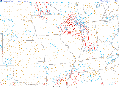
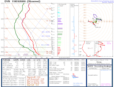
Decaying convection ahead of a small, compact shortwave trough provided a rather unique (and admittedly unexpected) chance for night photography (~10:30 PM) in my backyard. The environment was characterized by relatively robust CAPE in the lowest 3 km, with sufficient shear as noted by the 00z DVN sounding.
Although the rather impressive lightning display decided to quit as soon as I set up my tripod (figures!), I still managed to capture a few shots that I thought were pretty unique. As the small cell was approaching;
Yellow '+' indicates my position

light from a full moon in the low southeastern sky yielded enough light to produce a rainbow! I was shocked at first to see this, let alone find out later that it showed up in a couple of my pictures. The rest of the photo session was characterized by very stable air behind the cell where stars were shining like diamonds.
Moonbow! (hard to believe this was at 10:30 PM)
Dad taking in the view...
Facing south after cell passage

Ani-GIF of the Big Dipper (click to enlarge)