Monday, December 23, 2013

The Truth Is, You Gave a Lousy Forecast

"Of course I couldn't possibly be talking about you."

I'm resurrecting a blog title from an old TCHE article in light of recent snowfall forecasts (for the 12-21/12-22 period), most of which originated on Facebook and Twitter.  I hesitate to call these "forecasts," as they were simply regurgitated images of model output posted at face value, without any meteorological interrogation.  As an example, here is a popular image that was viral on social media sites by late Monday afternoon:

156 hr. "Total Snowfall" forecast from the ECMWF model initialized 1200 UTC December 16, 2013    
This eye-candy was often accompanied with hyperbole like, "LOOK OUT central IL!", or "Watching a major winter storm coming this weekend!"  For the meteorological novices reading,  this image is a forecast of "total snowfall" 6 1/2 days in advance from the European (ECMWF) model.  The image paints a heavy stripe of snow (~15-25 in.) from north-central MO through central IL and into northern IN.  You might be saying to yourself, "Uh, that didn't happen!"...and...you're right!  In fact, most of this region did not receive any snowfall from the most recent cyclone, as seen below:

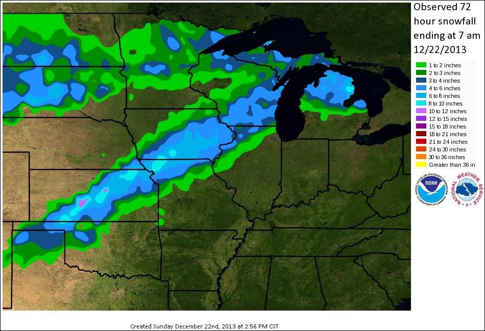
Actual snowfall verification from the 12-21/22-13 cyclone

 As you can see, the heaviest axis of observed snow fell roughly 200 miles further northwest than the model forecast and also totaled nearly 10 in. less in terms of magnitude.  

So, what went wrong?

Meteorologically, nothing!

While this was obviously a poor numerical weather model forecast, error only arises when a human interprets this solution as reality.  This is not necessarily a ploy to get people to stop posting such images (although that would certainly be nice!), rather I would like to see interrogation of the meteorological fields and discussions of features that would support or refute the forecast in question.  This is obviously not feasible on Twitter, yet I keep seeing such images posted.  Every snowfall. Every severe weather outbreak.  Pictures of various model fields with hype abound.  Where are the discussions of vorticity, thermal advection, and frontogenesis; or analysis of variables such as pressure, temperature, and specific humidity that are actually simulated by the governing equations driving the "sexy" model fields?  

They're around, just not on social media sites.  In fact, I closely followed the Area Forecast Discussions leading up to this event from WFO KLOT (Chicago) and KDVN (Davenport), and I must say they were quite impressive (you can find such discussions here).  Both offices discussed uncertainty in the model fields and provided physical meteorological reasoning behind their forecasts.  While these forecasts were far more accurate (in the true sense of the word), they were not the first forecasts for the event.  Similar to what many are seeing in main-stream journalism, there seems to be a rush to get the word out first, regardless of fact-checking or care for accuracy/precision.  It seems that simply being the first to announce a snowstorm a week in advance is more important than getting the forecast correct!

As the event drew closer, images kept popping up of  "snowfall" plots slowly shifting the axis of heaviest snow further northwest with each run.  I put "snowfall" in quotation marks, as this is not actually a post-processed model output field for the ECMWF, rather a simple 10:1 ice:liquid ratio multiplication, which can itself be a source of significant error depending on the vertical thermal profile.  These slow shifts to the northwest were not surprising to me, especially after analyzing low-level potential vorticity fields.

The point here is to suggest better communication practices for meteorologists when dealing with folks who may have little/no meteorological training.  Posting an image of 240 hr. snowfall as your forecast may draw you more followers, but where's the verification?  You're lucky most people have a short memory!  These posts are doing disservice to meteorologists everywhere and helping to perpetuate "the weatherman is always wrong" stereotype.  Forecasting is an imperfect science that should be expressed with probabilistic forecasts and associated uncertainty.

Let's strive to be better weather journalists.

Saturday, June 29, 2013

6/28/2013 High-based Supercell north of Seibert, CO

After awaking in Wichita, KS, we targeted northeast Colorado for a low probability of high-based supercells. The environment was characterized by a moderately unstable air mass (mostly due to steep low-level lapse rates. With such low surface dewpoints (upper 30s!), it was uncertain if any storms could become severe. While coming up on Burlington, CO, we noticed some towers to our immediate northwest. We turned north out of Seibert, CO, and latched onto a rapidly developing severe storm on state route 59 north of Seibert. We proceeded to chase this cell for a little over four hours! The storm displayed nice high-based structure and a very cool hail curtain. In fact, we sampled the hail curtain (when I felt the VIL was down to appropriate levels) and were able to find hail up to penny size. Overall, Friday was a successful and quite photogenic high-plains chase. Overnighted in Colby, KS.
Cool hail curtain north of Seibert, CO

Pretty high-plains sunset

Timelapse of the storm

Thursday, June 27, 2013

6/27/2013 Beloit Bomber

BLOG has been quiet as of late (usually a good sign for those who dislike severe storms), but our last CoD trip of the year had a pretty exciting day in north central Kansas on Thursday.  A convective outlook upgrade to a moderate risk for severe storms was in place by late morning, owing to large values of atmospheric instability and vertical wind shear.

We started the day in Lincoln, NE (Fairfield Inn) with an understanding that there would likely be ongoing convection in/near our area.  This essentially meant that we would have to drift southwestward to play a potential outflow boundary leftover from these morning thunderstorms.  After watching a fairly unimpressive elevated storm near Fairbury, KS, we booked it west toward Smith Center, KS, where towers were rapidly developing on the nose of steeper lapse rate air advecting from the southwest.  We didn't really expect the tornado threat to be too high this day as temperature and dewpoint spreads were unfavorable for tornadogenesis.  However, we were treated with nice supercell structure near Beloit, KS by late afternoon.  This storm had a "I'm about to do something nasty" appearance, and we were careful not to get to close this HP monster.  As we tried to stay ahead of the storm (now heading south on RT. 14), a barrage of some of the most intense CG lightning I have ever seen began to bombard us from all quadrants.  It was too dangerous to get out of the vans and try to take pictures but I assure you it was something out of a sci-fi movie.

As these storms began to congeal into a mesoscale convective system, we did our best to stay ahead of them by driving south on I-135.  We periodically stopped along the way for quick picture grabs, but the complex was easily keeping up with our interstate speed.  We found shelter along a sturdy brick building in Witchita, KS, before finally letting the complex move overhead.  Dang!  This line of storms snapped a 10" diameter tree branch right in our view (see video soon) and caused numerous power flashes.  We estimate that the winds were roughly 70 m.p.h. at this time, but it was hard to get exact measurements with so much surface friction in the downtown area.  Overall, not a bad day!

Overnighting in Wichita, KS.

About as close as this storm could come to tornadogenesis
Near Beloit, KS, looking west
Interesting shelf features
CG lightning as storm begins to surge to the southeast

Tuesday, June 18, 2013

6/14/2013 Dodge, NE Supercell

Walker and I targeted the area between Norfolk and Columbus, NE on this slight risk day. This region had strong surface convergence, moderate instability, and sufficient shear for supercells. The only concern was the strong capping inversion, which had us waiting in the Humphrey, NE park for a lengthy part of the afternoon. As strato-cumulus clouds took over, we became increasingly concerned about (the potential lack of) storms firing in our target region. We actually began to bail south toward less organized storms and, not even 10 minutes later, the first radar echo appeared northeast of Humphrey. We returned north and intercepted the slowly maturing storm near SR-91 and SR-15. The storm slowly matured into a majestic stack of plates supercell with numerous cloud-to-ground lightning strikes. The slow moving storm provided eye candy for a good hour or so, before convection to the south interacted with it, causing it to become increasingly disorganized. We punched west and then southwest toward Grand Island, stopping to take in a bit of lightning after sunset near Central City, NE. The night ended at a Fairfield Inn in Grand Island, NE (text modified from Walker Ashley).

Beautiful stack-of-plates supercell structure


Time lapse of the supercell

Monday, June 17, 2013

6/13/2013 Woodrow, CO Convection

Walker and I left DeKalb around 5 AM central with an initial target near Sterling, CO.  We weren't expecting supercells given the lack of vertical speed shear, but we thought storms may showcase an interesting view around sunset in eastern Colorado.  After dropping south out of Brush, CO, commencing a heckuva long drive on I-80 W, we soaked in a pretty view of developing convection near Woodrow, CO.  These storms provided a spectacular high-plains view for the next hour, before we slid east to stay ahead of the surging outflow winds.  These winds kicked up plenty of dust, including a few gustnadoes (see below).  We spent the night in Ogallala, NE, reminiscing about the spectacular scenery.


Mammatus on the high plains...ahh...

More mammatus

CG lightning strike

Bracketed exposure; probably one of my favorites so far this year
One of several gustnadoes observed
Timelapse of the day's convection

Friday, June 14, 2013

6/12/13 Mount Carroll, IL Tornado

Wednesday featured the first High Risk for severe storms across northern IL in nearly a decade.  It was nice to not be in a morning rush to get to a target area, as this was clearly going to be a "backyard" chase day.  I trekked over to DeKalb, IL around noon to pick up Walker Ashley (NIU; prof), Stephen Strader (NIU; Ph.D. student), and Matt Piechota (CoD; met student).  After glancing over some data, we jogged west toward Shannon, IL as a focus for an initial target.  Convection was beginning to form in all quadrants, and we wanted to make sure to "pick" the right storm.  We spent a few minutes time-lapsing a multicell storm southwest of Rockford, before heading toward the Rockford metro to latch on to a cell with a little better appearance on RADAR.  This new cell was quickly swallowed by a left-split produced by a supercell in southern DeKalb county (an impressive storm in its own right!).  We finally pit-stopped in Stockton, IL to grab a quick sandwich and monitor the RADAR.  While we were about to cut our losses and head back home, a new cell moving out of extreme eastern IA exhibited an interesting appearance and was drifting toward Jo Davies county in Illinois.  This area is less than ideal terrain for viewing storms, but it was really the only storm worth viewing at this point.  We latched on to this storm on Elizabeth road, roughly 8 miles northwest of Mount Carrol.  After finding a ridge to view from, it was clear that this storm exhibited numerous supercellular characteristics. We watched as a tornado formed (or perhaps was already in progress) roughly 7 miles to our northwest (still on Elizabeth road at this time).  We watched this tornado for ~10-15 min. before loosing sight of it due to poor terrain.  The next visual we had on the storm confirmed that our day was probably over.  Cool outflow was present at the surface, and it was clear that the storm was choking itself off. 

Oh, we still made it home to watch the Blackhawks play! 
Wide-angle view of the tornadic supercell northwest of Mount Carroll, IL (courtesy of Walker Ashley)

Initial view of the tornado (rain was making it difficult to see)


Look close and you can see debris in the sky...We later found out this was producing EF2 damage
Walker's Time-lapse


Matt's Video

Monday, May 27, 2013

5/26/13 LP Supercell east of Broken Bow, NE

Geesh!  Another day, another great structure show.  After sitting most of the day waiting for convective initiation in Arthur, NE, a few towers began to form to our east.  We scrambled after a dominant tower south of Broken Bow, NE, and we were treated with a great westerly view of the little precipitation supercell.  After getting east of the storm (and enduring 1.25" hail), we were treated with a beautiful view that allowed for a few chances at time lapse.  We watched this storm for a couple hours before heading to Kearney, NE for the evening to get some sleep (the next couple of days appear to be very active!)


Time lapse can be found here.

Sunday, May 26, 2013

5/25/13 Supercell north of Box Elder, SD

Wow!  What a structure fest.  Saturday featured some fantastic supercell structure in a slow moving environment that allowed for easy chasing.  We sat most of the day in Chadron, NE, before blasting north to a storm that was persistent north of Rapid City, SD.  This storm was HP, Classic, and LP, during it's lifetime and treated us to many beautiful views northeast of Rapid City.  Enjoy the pictures (and especially the time lapse) from Saturday!  These types of chase days are the best...

Dad taking in the great view...


Timelapse can be found here.

Saturday, May 25, 2013

5/24/2013 Holyoke, CO - Grant, NE Convection

A strengthening lee-side surface low was the play on Friday, with strong (20kt+) ESE winds into ne CO.  We watched towering cumulus from a park in Holyoke, CO, where I had the pleasure of meeting up the chase crew (Josh, Grady, et al.) from Western Kentucky University.  We watched the Holyoke cell most of the day and finally let it go near Grant, NE.  We also ran into CoD Trip 3!

I'm glad we let the storms shift to our east, as we were treated with some spectacular skies as sunlit mammatus and numerous cloud-to-cloud lightning strikes were plentiful.  A timelapse of our day can be found here.
Initial LP storm near Holyoke, CO

Beautiful sky near Grant, NE (looking east)


The REAL Mammatus!
Click for animated timelapse of convection.

Wednesday, May 22, 2013

5/19/2013 Edmond / Carney, OK Tornadoes

A moderate risk was in place for severe thunderstorms on the morning of 5-19 along a N-S oriented dryline in the Central Plains.  We had been eying Sunday's setup most of the week, and our plan was to play isolated storms along the dryline in central OK, as models had been hinting at robust thunderstorm development in that area for multiple runs.  Shear vector orientation (an important factor for storm morphology) was favorable in this area for isolated storms, and given the magnitude of the vertical wind shear (50+ kts.), isolated supercell thunderstorms appeared likely. 

We awoke in Wichita and immediately noticed an outflow boundary oriented E-W in central OK from our "Coldwater Cold Pool" the previous evening.
Morning Target "Tweet" (@gensiniwx)
We slowly drifted S along I-35 before stopping in South Haven, KS at a nice park for a softball game (1-0 good guys!).  After examining visible satellite for a couple hours and watching the 1800 UTC OUN sounding come in, we were excited that our morning forecast target may play out as planned.  Towering cumulus began forming near Oklahoma City, and we quickly loaded up to head south toward Edmond, OK.  The storm rapidly became a supercell before producing a tornado that hit Edmond (we watched a few power flashes as it moved through Edmond).

Tornado moving through Edmond, OK

What happened next was rather bizarre.  While navigating east out of the bears cage, we stopped at a house with a very long gravel driveway to turn around and face the storm for a view.  When it became apparent that the tornado was quickly moving toward this location, we dropped about 1/4 mi. south of this house and watched as it was struck!  Thankfully, the damage did not appear to be too bad, and to my knowledge, the residents were unscathed. 

After the rope out stage of the Edmond tornado, a new (much stronger) mesocyclone formed to the northeast of Edmond.  This storm had a much "meaner" appearance, and it was pretty evident that it was going to produce a large tornado...and it did.  The motions in this tornado were *violent*, in fact, more-so than in the video that I have seen of the Moore, OK tornadoes on May 20th.  This tornado had at least one large horizontal roll vortex, and appeared at one point to be two large tornadoes rotating around each other.

Wedge tornado near Carney, OK
 We stuck with this storm a little to long before dropping south to the storm that produced the Shawnee, OK tornado.  By the time we got there, that storm had become outflow dominant, but still treated us to many beautiful crepuscular rays at sunset. We ended the evening in Tulsa, OK, celebrating our great chase day and Morgan's (trip participant) 21st birthday.

5/18/2013 Coldwater Cold Pool

5-18 featured a dual dryline structure across portions of S central KS.  After sitting in Greensburg, KS for nearly an hour, we got suckered south to an area of clumpy towering cumulus that were forming in steeper lapse-rate air coming out of the TX/OK panhandle area.  Once this convection crossed the boundary into substantially greater surface theta-e values, we were interested to see what would happen.  Turned out that a large cold pool was already established before moving into this area and all we were able to view was an outflow dominant cluster of sub-severe storms.  We made a decision to head south for the better environment, yet a storm formed north of Greensburg that produced a nice tornado.  Storm morphology really killed us this day.

Tuesday, May 21, 2013

Moore, OK Tornado Warning: Upon further review...

I need to catch up on sleep and process some pictures from 5-19 (it has been a long ten days on the road with Trip 2), but I wanted to clear the air of some erroneous claims and facts that I have been hearing about yesterday's (5-20-2013) tornadoes in OK.  I've heard everything from "no warnings were issued" to "lead time was 45 min."

First, let me preface by saying I was not chasing on this particular day.  Sunday was the last day of our trip and we *had* to come home Monday afternoon.  However, the drive back to Chicago allowed me to watch the events in Moore, OK unfold with a keen eye.  Luckily, I archived a lot of data and am just now starting to sift through some of it.

The media reporting of the warning aspect of this storm is particularly troubling to me (in addition to many other rediculous claims certain local Oklahoma City stations were blurting out).  That discussion is for another post.

Let's take a further look into the timeline of the Moore, OK tornado warning:

5-20-2013 19:40 UTC   WFO OUN issues tornado warning (red polygon) including the city of Moore. 

I have included the 19:40 UTC tornado warning polygon and the 19:38 radar suite (BREF image shown) that likely prompted the tornado warning.

19:38 UTC BREF & Tornado Warning Polygon

At 20:01 UTC, WFO OUN issues a tornado emergency for the town of Moore.

At 20:16 UTC, the tornadic circulation was just southwest of Moore (probably just entering town around this time). 

20:16 UTC BREF and initial tornado warning polygon
20:16 UTC SRV (258 @ 23kts) and initial tornado warning polygon
Via radar, it appears the tornadic radar signature was in Moore around 20:20 UTC. 

20:21 UTC SRV and initial tornado warning

So, taking this approach (which I will agree is not the "T"ruth), this puts the tornado lead time for the folks in Moore at roughly 40 minutes! Not this bull#$%* I am hearing about 10-15 min! Even the tornado emergency had nearly a 20 minute lead time for Moore.  This was a great tornado warning by the same great forecaster who issued a tornado warning back on 3 May 1999 for an eerily similar situation.

Obviously, not all locations in the warning receive the same lead time.  It is a function of how far you are away from the tornado when the initial warning is issued.  This can make the lead time for a particular warning tricky.  If you score this on a city-by-city basis, then Moore has an amazing 40 minute lead time for this event. Hats of to the Norman, OK National Weather Service Office for a job well done!

It disgusts me how inaccurate journalists are becoming (see recent Boston Marathon bombing timeline).  Everyone races to the answer without doing the important detective work.  Ratings baby!

While I have your attention...consider donating to the central Oklahoma chapter of the Red Cross.  I had a pit in my stomach most of the day yesterday after hearing about the situation with the elementary school children.  The photos speak for themselves.

This is why I'm a severe storms scientist.

Now back to regularly scheduled blogging.

Saturday, May 18, 2013

5/17/2013 Ellsworth, NE Convection Timelapse

COD's Trip 2 watched a nearly stationary storm for an hour in northwest NE on Friday afternoon.  This area is always a tough place to chase storms, because of the hilly terrain of the Nebraska Sandhills.  However, the area we stopped to watch this storm provided a unique opportunity to time lapse passing trains and convection spreading eastward toward our location.  At one point (during the end of the timelapse), this storm began to develop supercell characteristics, but then was quickly undercut by its own outflow due to a lack of vertical speed shear. Enjoy the timelapse!

Tomorrow should be a pretty interesting day across southern KS as the eastern fringe of the jetstream begins to overspread the central Plains.  Our current target is Pratt, KS for some significant storms around sunset.  Check back soon for updates.

5/17/2013 Ellsworth, NE Convection Timelapse

Friday, May 17, 2013

5/16/2013 Storm Intercept in Northwest KS

We intercepted a severe thunderstorm warned storm in northwest KS on Thursday afternoon.  We didn't stay to watch long, as we headed north to set-up for Friday's chasing opportunities in South Dakota. Make sure to watch the YouTube video in High Definition!

High-based pretty convection

http://www.youtube.com/watch?v=IsQf6pRNv0g

5/15/2013 Weatherford, TX Tornadic Supercell

Wednesday featured a unique setup in northwesterly flow behind a closed upper-level low pressure system migrating eastward over Oklahoma.  In short, we documented three tornadoes.  I hope to have better video after the season concludes and I can process it.  Until then, enjoy videos from our group:

http://www.youtube.com/watch?v=aSxauC_CIf0

http://www.youtube.com/watch?v=HaM2f17aK88

Rapidly Rotating Rugged Wall Cloud
Tornado!
Hello clear slot!