A fairly inactive 2014 for tornadoes was thrown for a spin on 6-16. Piechota and I left northern Illinois by 6:30 AM with a broad target of northeast NE / northwest IA. As we rounded Omaha, NE, a Particularly Dangerous Situation (PDS) tornado watch was issued for northeast NE and extreme western IA by the
Storm Prediction Center for areas along/near a retreating morning outflow boundary:
URGENT - IMMEDIATE BROADCAST REQUESTED
   TORNADO WATCH NUMBER 303
   NWS STORM PREDICTION CENTER NORMAN OK
   310 PM CDT MON JUN 16 2014

   THE NWS STORM PREDICTION CENTER HAS ISSUED A

   * TORNADO WATCH FOR PORTIONS OF
     WEST-CENTRAL IOWA
     NORTH-CENTRAL AND NORTHEAST NEBRASKA

   * EFFECTIVE THIS MONDAY AFTERNOON AND EVENING FROM 310 PM UNTIL
     1000 PM CDT.

   ...THIS IS A PARTICULARLY DANGEROUS SITUATION...

   * PRIMARY THREATS INCLUDE...
     SEVERAL TORNADOES AND A FEW INTENSE TORNADOES LIKELY
     SCATTERED LARGE HAIL LIKELY WITH ISOLATED VERY LARGE HAIL EVENTS
       TO 3 INCHES IN DIAMETER POSSIBLE
     SCATTERED DAMAGING WIND GUSTS TO 70 MPH POSSIBLE

   THE TORNADO WATCH AREA IS APPROXIMATELY ALONG AND 55 STATUTE
   MILES NORTH AND SOUTH OF A LINE FROM 25 MILES SOUTH SOUTHWEST OF
   AINSWORTH NEBRASKA TO 20 MILES EAST NORTHEAST OF TEKAMAH
   NEBRASKA.  FOR A COMPLETE DEPICTION OF THE WATCH SEE THE
   ASSOCIATED WATCH OUTLINE UPDATE (WOUS64 KWNS WOU3).

   PRECAUTIONARY/PREPAREDNESS ACTIONS...

   REMEMBER...A TORNADO WATCH MEANS CONDITIONS ARE FAVORABLE FOR
   TORNADOES AND SEVERE THUNDERSTORMS IN AND CLOSE TO THE WATCH
   AREA. PERSONS IN THESE AREAS SHOULD BE ON THE LOOKOUT FOR
   THREATENING WEATHER CONDITIONS AND LISTEN FOR LATER STATEMENTS
   AND POSSIBLE WARNINGS.

   &&
The morning potential for surfaced based supercells was a little unclear, with a fairly large spatial area destabilizing underneath more than adequate deep-layer shear for supercells. However, by mid afternoon it was clear we wanted to be near Norfolk, NE as cumulus began to bubble along the retreating outflow boundary. LCLs were manageable in this region for tornadic activity, all we needed was a storm. The special afternoon weather balloon launch out of Omaha reiterated the enhanced threat of tornadoes given the extreme instability present and the large looping low-level hodographs. You don't see an observed sounding with a Supercell Composite value over 60 and an effective-layer Significant Tornado Parameter over 10 very often...
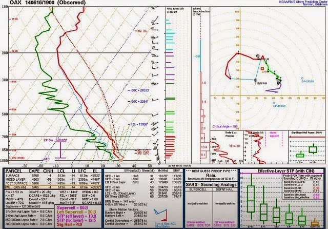 |
| June 16th 2014 1900 UTC radiosonde launch from Omaha/Valley, NE (KOAX) |
 |
| 4:24 PM CDT visible satellite and supercell composite! |
The aforementioned towering Cu continued to strengthen, but with a rather benign RADAR appearance. The initial cell was certainly elevated, both by RADAR and visual appearance, but QUICKLY became surfaced based as it began to ingest vorticity rich air near the overnight OFB. After a few lightning strikes, it was clear this storm was off to the races (you can actually hear us mention this at the very beginning of the video below).
We drifted with the cell southwest of Stanton, NE where a nice clear slot began to develop. The cell had that 'look' and it was apparent that tornadogenesis was underway. In perhaps one of my funnier moments, I ran into fellow chaser Dave Ewoldt (I had never met him before outside of social media) and said very calmly, "I think we picked the right storm." Indeed we did.
 |
| First tornado near Stanton, NE |
As the Stanton tornado began to occlude, we jogged east on Golf Course Rd. as a wedge tornado occluded north of Stanton (see our video below) to reposition for a new developing mesocyclone southwest of Pilger, NE. We stopped a mile west of NE HWY 15 watching a new developing tornado as the rear-flank downdraft began to surge just to our immediate north (you can see the wrapping rain curtains during this time in the video). After the surge, the tornado became steady-state headed on a direct course for the town of Pilger.
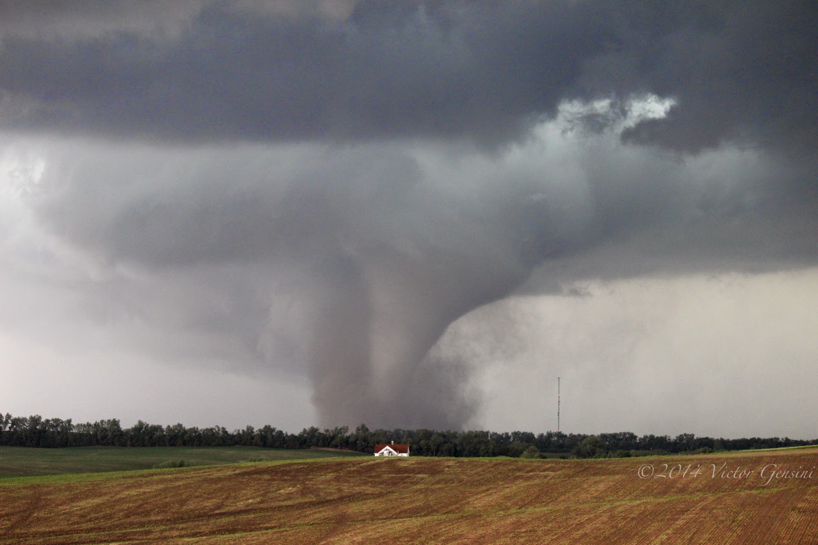 |
| Tornado just southwest of Pilger, NE |
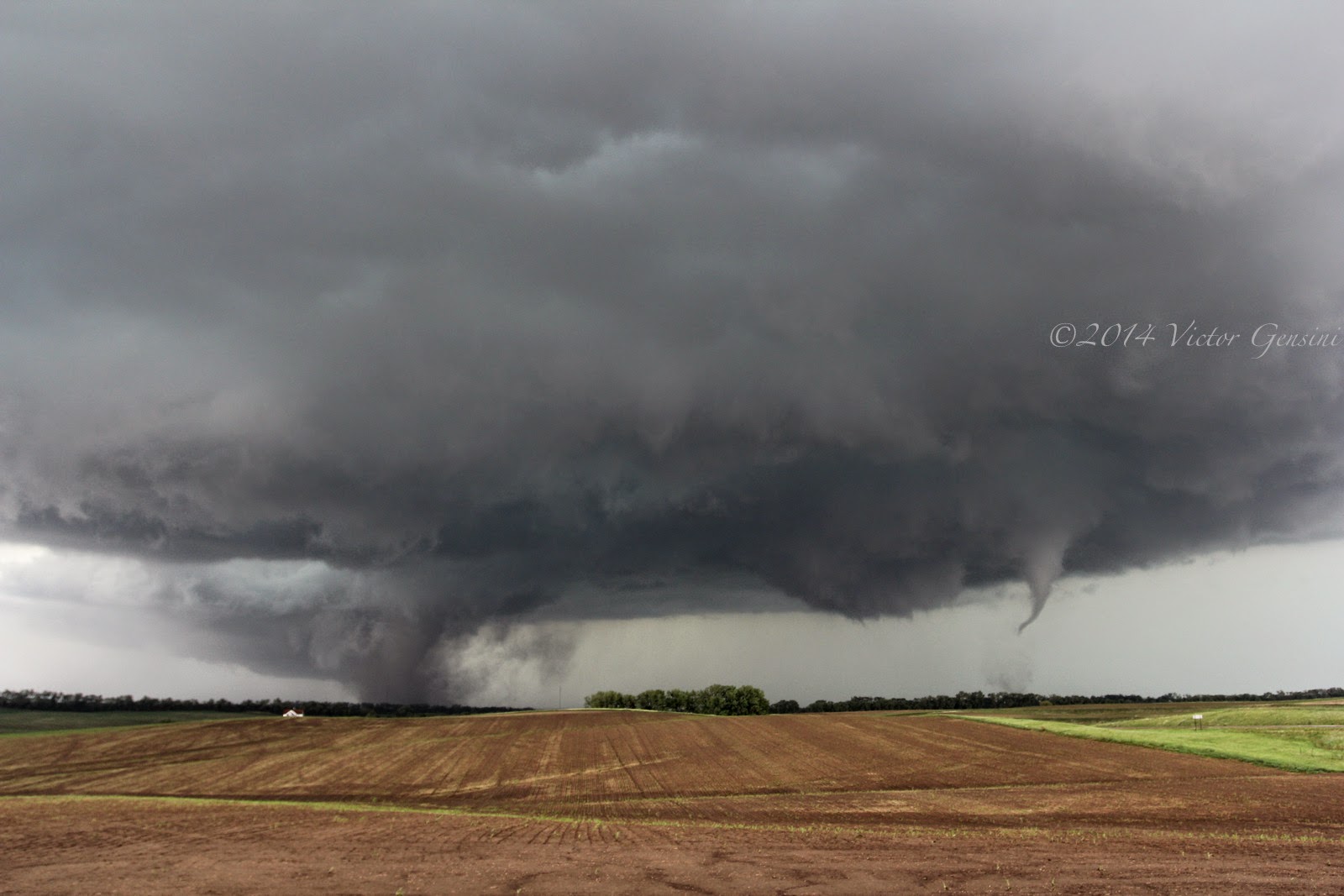 |
| Tornado entering Pilger with new tornado developing to the east. |
As the tornado headed into Pilger, a second mesocyclone developed and another large tornado formed just east of the Pilger tornado.
 |
| Two strong tornadoes now in progress (one exiting Pilger, the other roughly a mile to its east) |
 |
| Pilger, NE wedge tornado at the end of its lifecycle | |
| |
| |
| |
| |
| |
We cut north to Wisner, NE and took HWY 51 east before heading back to the north to see a new developing tornado just west of Pender. This tornado got large rather quickly and also had a smaller satellite tornado that revolved around the main tornado cyclone.
 |
| Beginning of wedge tornado west of Pender, NE |
In all, we witnessed 5 tornadoes that occurred in northeast Nebraska from a safe distance, including the unfortunate killer tornado that hit Pilger. An exciting, but sobering chase day.


.jpg)


