Saturday, June 27, 2015

6/22/2015 Woodhaven Lakes EF2 Tornado

Monday was what I would consider a climatological pattern for tornadoes across eastern IA, northern IL, and southern Michigan.  As is often the case with these setups, ongoing thunderstorms in the morning 'muddied' up the forecast (things were not clear even by mid-afternoon!), but severe thunderstorms eventually developed across the risk area by early evening. We targeted the DVN area, then slid a tad north a strengthening storm west of Clinton, IA. This storm morphed into a strong supercell after crossing the MS river, but poor visibility made identifying the storm structure difficult.  This storm continued to grow into a large high-precipitation (HP) supercell before diving southeast across north-central IL and producing numerous tornadoes.  We had several great views into the notch, but really could only confirm one touchdown of a tornado.  We bailed on the storm near Mendota, IL as it was becoming dark/dangerous.

We (Matt Piechota and I) came back out to the hard hit Woodhaven Lakes area on the 23rd to conduct a storm survey on behalf of the National Weather Service in Chicago. We found several areas of EF2 damage in Woodhaven Lakes.  Thankfully, only minor injuries and no fatalities were recorded here (likely because it was not a weekend).  This was an extremely vulnerable campground area, and we found many campers crushed by large pine trees.  Many of the residents again commented that the WEA cellphone warnings from the NWS helped alert them (with ample time) to the pending tornado.  I consider this another huge success story for the region.  

Survey Summary:
.TORNADO #5: WOODHAVEN LAKES/SUBLETTE TORNADO

RATING:                 EF-2
PEAK WIND:              130 MPH
PATH LENGTH:            7.8 MILES
PATH WIDTH MAXIMUM:     ONE HALF MILE
FATALITIES:             0
INJURIES:               7

START DATE:             JUN 22 2015
START TIME:             753 PM CDT
START LOCATION:         4.0 MILES SOUTH OF AMBOY IL
START LAT/LON:          41.6565 / -89.3213

END DATE:               JUN 22 2015
END TIME:               811 PM CDT
END LOCATION:           3.4 MILES SOUTHEAST OF SUBLETTE IL
END LAT/LON:            41.6044 / -89.1874

SURVEY SUMMARY: VERY SIGNIFICANT TREE DAMAGE...WITH MANY LARGE
TREES SNAPPED OR UPROOTED IN WOODHAVEN LAKES CAMPING RESORT AREA.
SEVERAL OF THESE FELL ON RECREATIONAL VEHICLES.

NOTES: THIS WAS THE STRONGEST TORNADO DAMAGE RATING WITHIN LEE
COUNTY ITSELF SINCE AN F2 TORNADO ON JULY 8 1993. THE THREE
TORNADOES IN LEE COUNTY WERE THE MOST IN ONE CALENDAR DAY IN THE
TORNADO PERIOD OF RECORD /SINCE 1950/.

GENSINI/PIECHOTA

Late morning tornado outlook and associated verification from the SPC
200 image RADAR loop from KDVN
Looking west near Sterling, IL
Select damage pictures from Woodhaven Lakes:


Talking with Gov. Rauner following the damage survey

Friday, June 26, 2015

6/21/2015 Lodgepole to Bison, SD Tornadoes

6-21 was a great storm observation day in northwest South Dakota.  The morning observations/satellite imagery led me to paint this target:
Morning tornado forecast (X indicates my forecast for convective initiation)
Fortuitously, convection developed just a few miles west of our target, and tracked southeasterly with the steering winds:

We waited in Marmarth, ND for the maturing convection due to the poor road network and we did not anticipate tornadogenesis until the storm reached the better 850 hPa moisture and winds. We did get to see some cool Kelvin-Helmholtz instability waves while waiting for the storm to approach.
KH Waves
As *soon* as that storm reached the better moisture, it went on to produce 4 tornadoes (one a large dusty bowl shape) from Lodgepole to Bison, SD. I think we played the storm just right with regards to the road network, and were handsomely rewarded with some great stills, lapse, and video.  We put the cherry on top by photographing decaying Cb and associated lightning in the twilight. Certainly one of the best chase days of 2015! 
Initial supercell
Tornado # 1
Ropeout of tornado # 1
Tornado #2
Recycle after tornado # 2
Tornado # 3
Continuation of tornado # 3
Tornado # 4
Letting the cell drift away (looking east)


6/20/2015 WY/SD/NE Tri-State Supercell

We tacked a long-lived supercell on 6-20 starting west of Newcastle, WY and ending near Chadron, NE.  This non-tornadic supercell (due to LCL height and low-level shear) gave us over six hours of vistas and entertainment after starting the day in Wall (with no power due to the wind damage from the previous evening).  We took a scenic route through the Black Hills and grabbed an awesome lunch in Hill City at a rooftop pub/grille.  Convection developed just west of our target (Newcastle, WY) and we stayed with it the rest of the evening through South Dakota and into Nebraska.  A great day!

MISC: Overnighted in Alliance.

RADAR loop from UNR of the event
Our location (green 'x'), station plots, and visible satellite at peak supercell intensity


Sunday, June 21, 2015

6/19/2015 Moorcroft, WY LP Supercell

Friday featured anomalously high dewpoints for northeast WY and adjacent areas of southeast Montana for severe convection.  Awaking in Miles City, MT, we drifted (took a gravel road shortcut ;]) south toward Gillette, WY.  We met up with the CoD crew to launch a radiosonde from Gillette (data posted below).  The sonde launch was telling, mostly because of the high LCL/LFC of the environment sampled (due to very high T/Td spreads), expressing the low likelihood of tornado producing thunderstorms.  Given this, we chose to stay near GCC and await a nice TCu signal just to our west along the Bighorn Mountains.  This cell eventually matured into a beautiful LP supercell near Moorcroft, WY (see timelapse below).

As our LP began to decay (see RADAR loop), we pushed east toward Spearfish with hopes that a long lived cell originating in the Broadus, MT area would be able to reach the better surface moisture/winds and become tornadic.  Now east of Rapid City, this storm became significantly tornadic with strong gate-to-gate shear and a CC debris signature noted on RADAR.  We stayed ahead of this storm until our hotel location of Wall, SD, with a few in between to take in the majestic storm.  We took shelter in Wall as the storm hit, knocking out power to the entire town with large hail and winds reported near 90 mph.  Definitely a night I will never forget!

MISC: Overnighted (with no power) at the Frontier Cabins in Wall, SD.

Morning severe weather target forecast
Verification of severe weather reports
College of DuPage NEXLAB radiosonde launch from KGCC (21 UTC)
MLCAPE (colored contours) and visible satellite. Our position is the green 'x'
200 image RADAR loop from KUDX (Rapid City, SD)
A rare 'PDS' T-storm watch from the Storm Prediction Center
LP Supercell near Moorcroft, WY
Monster tornadic supercell after dark northwest of Wall, SD

LP supercell lapse

Thursday, June 18, 2015

6/17/2015 Broadus, MT to Gillette, WY Severe Storms

MOTS (More Of The Same) for our group on Wednesday.  A broad area of marginally favorable ingredients for severe storms were forecast from Cheyenne to Broadus.  We favored the northern target, with slightly better deep layer shear for organized convection.  Mid-level height rises were found over most of the area until very late in the afternoon.  After hanging most of the afternoon in Gillette, we ventured north to intercept a supercell moving southeast of east central MT.  On the way, we took in the vistas with a developing LP type supercell to our immediate east.  This towering Cu made for a nice backdrop of the Wyoming countryside!  Continuing north, we latched onto our original target cell near Broadus, MT.  It was mostly a disorganized HP type of supercell, but provided some neat shots before congealing into a forward propagating MCS heading for the Black Hills.  On our way back to Gillette, we encountered gusty winds found 2" hailstones covering the ground north of Weston.  In all, another successful day on the High Plains!

MISC: Overnighted in Gillette, WY. Do not get a taco bag from Taco Johns. Do, however, get the Potato Ole's! 

Early baby cell developing northeast of GCC
Broadus, MT storm at peak isolated intensity


Tuesday, June 16, 2015

6/16/2015 I-25 Severe Storms

Tuesday featured another slight risk along the Laramie Range and we decided to hug this play due to the rather marginal ingredients elsewhere, and the slightly better upper level wind shear over the northern target (plus, we awoke in the target area!).  After some McAlisters Mac ‘N Cheese (YUM; thanks Laura!), we ventured out of Laramie toward Glendo State Park.  We found a perch in the state park that overlooked a reservoir (kudos to Walker for remembering this spot) and captured some stunning images of a developing LP type supercell to our immediate north.  We repositioned south a few times to take in more views of the gorgeous updraft. A longer stop transpired west of Guernsey, WY, to take in the sky for a bit before ping-ponging back and forth between Chugwater and Dwyer.  This turned out to be rather fortuitous though, as we found a majestic bald eagle to photograph!

New storms were developing west of the Laramie Range, so we bolted back north toward Guernsey to a gravel road where we had previously shot some nice time lapse photos.  We allowed the core of this last (and beefy!) storm to pass just to our west before driving back toward I-25 to look for large hailstones.  The largest stones we could find were near 2.5” at the rest stop just west of Dwyer. Rather large hail for this area of the country!

We ended the day with a nice skyscape on our drive to Casper to position for Wednesday.  

MISC:  Overnighted in Casper, WY.
Pano view from Glendo St. Park
Severe storm near Guernsey, WY
High based funnel taken from I-25 looking east (somewhere south of Dwyer, WY)
Bald eagle! 
Significant severe hail from the Dwyer, WY rest area
Holding some grade 'A' farm fresh hailstones

6/15/2015 Elk Mountain, WY Tornadoes

We awoke in Cheyenne to an 'interesting' risk for severe storms in the interior of WY. Moisture was pooling on the west side of the Laramie Range, along with clearing skies and a fairly strong northeasterly surface wind.  To kill time prior to convective initiation, we visited the Snowy Range Pass (~11,000 ft. elevation) where plenty of snow was still to be found. After stopping for some neat shots near Lake Marie in the Snowy Range Pass, 
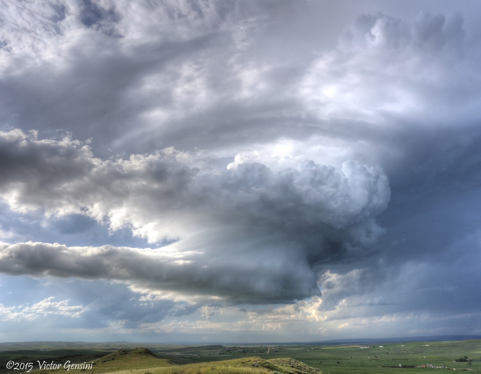
we completed the circuit and watched developing convection near Rawlins, WY from the Elk Mountain, WY area.

The convection was ‘pretty’, but never really had a tornadic appearance. However, when driving east away from these storms on HWY 72 near Rock River, the storm suddenly pulsed up an started to feature a cone shape lowering now 15-20 miles to our west near Elk Mountain.  We stopped at a nice vista east of Rock River to watch the developing tornado.  The tornado started around 3:47 local time and was nearly continuous until 4:03 PM.  A second, smaller, rope tornado also formed around 3:53 PM just to the northeast of this first tornado.

We repositioned just south of Rock River to get a better view of this tornado and were treated with a great view (next to a fox that called a drainage pipe along the road his/her home!)

These tornadoes were rather unexpected, and after further analysis, likely formed due to a local vorticity maximum associated with strong northeasterly winds into the area (see image below).  A storm-scale boundary may have also played a role in tornadogenesis, as these storms were a ‘one and done’.  A fun and rather unexpected high-plains surprise!


MISC:  Overnighted in Laramie, WY.  This is currently my highest recorded elevation of a tornado.  We estimate that the Elk Mountain, WY tornado occurred at an altitude of 7,300 ft. ASL!

Snowy Range Pass lookout tower
Lake Marie in Snowy Range Pass

KCYS Base Reflectivity RADAR loop
Surface obs, visible satellite, and vorticity (tan contours). Green 'x' is our location.