Tuesday, June 27, 2017

6/21/2017 Beaver City, NE Euphoria

Wednesday was just one of those days that will be hard to ever replicate. After a long afternoon/evening waiting for severe storms to develop in Norton, KS, we sat up shop just south of Beaver City, NE, to photograph convective towers and sunset. We were treated with nearly 5 1/2 hours of great skyscapes (e.g., sunlit towers, ACCUS @ sunset, continuous lightning, stars, Milky Way). We sat in the same spot (with only one car passing!) from 8:00 PM CDT to just after 1:30 AM CDT filling up memory cards with picture after picture for timelapse. We were definitely high on life! Another day I will never forget, and a great end to ACP 2017! 

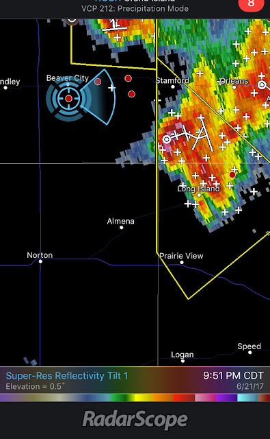
Our position and bearing
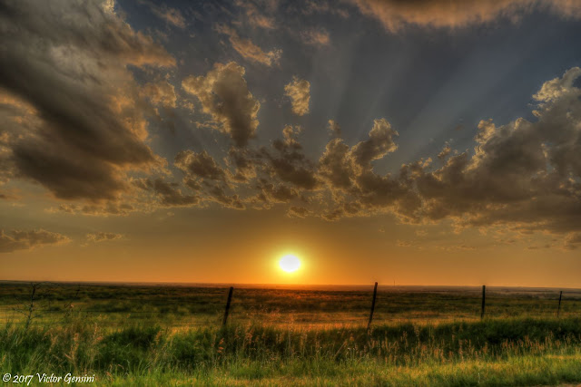
Sunset facing west


Milky Way! 

Wednesday, June 21, 2017

6/20/2017 Ulysses to Big Bow, KS Severe Storms

Tuesday featured a targeted slight risk of severe thunderstorms across west central Kansas. We were not expecting any tornado potential as the dewpoint depression values were well over 30 F by late afternoon, but severe weather did form in our target area east of Leoti, KS. We saw some great structure on a developing quasi-supercell that produced 2.75" hail in several locations throughout its lifecycle. Most of the photos below are from near Ulysses, KS, with the exception of the railroad shot (one of my favorites from this day). That picture was taken near Big Bow, KS. We also documented wave breaking with a left split moving toward our location. Walker's timelapse of this should be outstanding...

We went through Ulysses after the storms passed, and it was easy to see the vegetation damage and even a snapped power pole north of town. Another amazing day in America's heartland! 

MISC: Overnighted in Garden City, KS. 


6/19/2017 Rio Grande River Gorge

We suspected the cap would be too strong for convection (given the limited upslope winds), so we spent our day bouncing around the Spanish Peaks. We spent some time in the very cool town of Taos, NM before dipping through the Rio Grande River valley and crossing the Rio Grande pass bridge. A day filled with great scenery, friends, and itchy chigger bites!

MISC: Overnighted in Trinidad, CO.


6/18/2017 Picture Canyon, CO and Raton Pass

On Sunday we took the opportunity to visit Picture Canyon (a small state park near Campo, CO) as we were passing through toward Trinidad. This location had some very neat pictographs and petroglyphs, They are believed to be artifacts from the Plains Indians (c. 1650). We then enjoyed a leisurely drive through the Raton Pass in northeast NM, stopping periodically to take in the sky. 

Overnighted in Trinidad, CO.


Tuesday, June 20, 2017

6/17/2017 Cosgrove to Wichita, KS Supercell and Shelf

Saturday’s setup was another typical 2017 setup, with outstanding instability but rather lackluster low-level wind shear. After killing some time in Salina, we drifted north to rapidly developing towers south of Junction City, KS. They had some good initial structure and were throwing out copious positive CG bolts, but cold pools quickly consolidated into a forward propagating MCS. We stayed ahead of the bow from Cosgrove to Wichita, occasionally stopping for photos of the shelf and attempts at lightning.


MISC: Overnighted in Wichita, KS


Saturday, June 17, 2017

6/16/2017 Tilden, NE Tornado and Fairmont, NE Skyfire

Friday was one of those chase days that comes around only a handful of times per year. Awaking in Hutchinson, KS, we eyed a potential target of Norfolk, NE along a gently drifting density discontinuity. After waiting in the (nice) Albion, NE park, we shifted north to developing cumulus congestus northwest of Norfolk. The initial cell had a distinct lowering from rain cooled air being ingested from the forward flank.  It continued to strengthen, and to our surprise, developed strong rotation and a brief tornado near Tilden, NE. Precipitation from a new cell to the west was too much to overcome though, and it was pretty clear from our perspective that the complex was becoming outflow dominant. We shifted to structure photography mode and began setting up for sunset and lightning opportunities. This really payed off, as we witnessed an absolutely spectacular lightning show just east of Fairmont, NE. This was a top 5 lightning show for me, filling up two 32GB memory cards with photos and timelapse images. As if it could not get any better, the sky was full of mammatus to our east, a pretty sunset to our west, and infinite numbers of fireflies dancing in the fields among us. A day I will never forget. Make sure to watch the timelapse until the end!

MISC: Overnighted in Lincoln, NE - Met up with Skip and Brindley for HUGE pizzas.

Strong rotation and a dust swirl near Tilden, NE (lasted 1-2 min)


6/15/2017 Hutchinson, KS Mammatus

Thursday was mostly a bust from a storm photography perspective (lackluster structure despite several severe and tornado warnings), so we grabbed a hotel in Hutchinson, KS ahead of a developing severe MCS. After this passed over us, we photographed some spectacular mammatus at sunset. However, we were at dinner and none of us had our DSLR cameras! A lesson to always have your camera by your side! At least cell phone cameras are pretty good these days...

MISC: Overnighted in Hutchinson, KS